Text this colour links to Pages. Text this colour links to Family Trees. Text this colour are links that are disabled for Guests.
Place the mouse over images to see a larger image. Click on paintings to see the painter's Biography Page. Mouse over links for a preview. Move the mouse off the painting or link to close the popup.
West Kennet Long Barrow is in West Kennet, Wiltshire, Avebury Long Barrows.

West Kennet Long Barrow [Map]. Photo from https://hpedersen.tumblr.com/post/48840729825/aenglaland-the-west-kennet-long-barrow-is...
West Kennet Long Barrow [Map] is a Severn Cotswolds Tomb type tomb, probably constructed in the 3700s BC. Human bones of men, women and children were placed in the chambers between 3670 and 3635 BC. The site appears to be subsequently re-used between 3620 and 3240 BC. In the late Neolithic it was blocked up with the addition of large sarsen boulders. It is 100m in length, 20m wide, constructed from earth with ditches on both sides, oriented east-west. At the east end are multiple chambers formed off a passage that extends 12m into the barrow. The ceiling is between 1.7 and 2.2m high - sufficient to allow an adult to stand upright.
Finds included Grooved Ware, Beaker Ware, Ebbsfleet Ware, Mortlake Ware and Fengate Ware coming from more than two hundred and fifty vessels.
Avebury by William Stukeley. 1723. But even this is much exceeded in south long barrow [West Kennet Long Barrow [Map]], near Silbury-hill [Map], south of it, and upon the bank of the Kennet. It stands east and west, pointing to the dragon's head on Overton-hill. A very operose congeries of huge stones upon the east end, and upon part of its back or ridge; piled one upon another, with no little labour: doubtless in order to form a sufficient chamber, for the remains of the person there buried; not easily to be disturbed. The whole tumulus is an excessively large mound of earth 180 cubits long, ridged up like a house. And we must needs conclude, the people that made these durable mausolea, had a very strong hope of the resurrection of their bodies, as well as souls who thus provided against their being disturbed.
Upon the heath south of Silbury-hill [Map], was a very large oblong work, like a long barrow, made only of stones pitched in the ground, no tumulus. Mr. Smith beforementioned told me, his cousin took the stones away (then) 14 years ago, to make mere stones withal. I take it to have been an archdruid's, tho' humble, yet magnificent; being 350 feet or 200 cubits long.

Avebury by William Stukeley. Table XXXI. The Long Barrow S. of Silbury Hill [West Kennet Long Barrow [Map]]. An Archdruids barrow.
Diary of a Dean by Merewether. 4th August 1849. Saturday, the 4th of August, was in the morning chiefly devoted to Silbury [Map]; and it was arranged that I should be left in charge, as the examination of the centre was every hour becoming more and more critical and interesting. After due consultation respecting Silbury, our steps were directed to a singularly interesting object, described as an Archdruid's barrow [West Kennet long barrow [Map]], lying three quarters of a mile south-east of Silbury Hill [Map]. This appellation I suppose has been adopted from Stukeley; it ranges about east and west, and is at least 150 ft. long, higher and broader at the east end, where it is 30 ft., than at the west. It had evidently been cut through on the ridge in several places, but not improbably, in most instances, merely for agricultural purposes. At the east end were lying, in a dislodged condition, at least 30 sarsen stones, in which might clearly be traced the chamber formed by the side uprights and large transom stones, and the similar but lower and smaller passage leading to it; and below, round the base of the east end, wre to be seen the portion of the circle or semicircle of stones bounding it. There are two other barrows of this kind in the neighbourhood, which I may mention in this place; the one [East Kennet Long Barrow [Map]] about three-quarters of a mile south-east of that just described, which is of much the same character as to shape and dimensions, but differs in construction. I was induced to visit this in consequence of having been informed by the occupier of the surrounding land, that he had caused a hole to be dug at the east end for the purpose of obtaining flints; but that he soon found that it was made up of round and generally flat sarsen stones, which came tumbling so about the men that they gave up the work. It has unfortunately been planted over, as have many of the larger barrows on Hacpen Hill; I think in bad taste. The other is situated on Alton Down [Adam's Grave [Map]?], south of Wansdyke: all these range in the same bearing, south-east by north-west. It is 130 ft. long by 30 high. This is still covered with turf, and has been opened about half-way along the ridge, but not effectually. It is remarkable for having, about half-way down the slope of the east end, a sarsen stone; another at the base in the centre. On the south side, in the trench formed by raising the mound, is a very curious earthwork, in form an oval, with a mound about 2 ft. high round it, and a sarsen stone in the centre; the whole about 40 feet long by 15 broad. In advance of the barrow eastward, and at its very base, is another earthwork, of similar height as to its mound, in a line at right angles with the central line, about 30 ft. long, with a return of 10 ft. on either side. These two curious objects I visited at so late a period of my Wiltshire sojourn, that I could not indulge in the gratification of examining them. It is a satisfaction to mention these three, in the hope that it may lead to the disclosure of their interesting contents at some future day.
![]() Become a Member via our Buy Me a Coffee page to read more.
Become a Member via our Buy Me a Coffee page to read more.
Wiltshire Archaeological Magazine 1857 V4 Pages 307-363. Barrows, Etc., In The Neighbourhood Of Abury
In perfect keeping with the genius loci [kind of place], are the numerous barrows which crown the hills and stud the plains which surround the village of Abury. On the Windmill, Overton, and Hakpen Hills, are several of various dimensions and elegant form. On the elevated ground between the Kennet Avenue and Silbury Hill, which in Stukeley's book is called Weedon Hill and Windmill Boll, were others, but the plough and cultivation have obliterated these, as well as many other interesting antiquities which were in existence at the time he wrote. Of several long barrows which he described, the most remarkable at the present time is that on the brow of the hill south of Silbury [West Kennet Long Barrow [Map]]. It is about 300 feet long and 35 feet wide, and is called the Long Barrow. At the east end are about 40 large sarsens (one of them is 11 feet long and 6 wide, another is 9 feet long, 7 broad, and 2 thick) lying confusedly one over the other. They doubtless originally formed achamber. A farmer cut a waggon drive through this barrow, some time ago, much to the annoyance of his landlord.1
Note 1. This barrow deserves a careful and thorough examination, and when the Wiltshire Archæological and Natural History Society hold their meeting at Marlborough, they would do well to turn their attention to it, and apply for permission to open it. Aubrey gives rude sketches of this and the Mill barrow.

Archaeologia Volume 38 1883 Section XXVII. On The Examination Of A Chambered Long Barrow At West Kennet [Map], Wiltshire. By John Thurnam (age 49). Read 15th March, 1860.

Wiltshire Archaeological Magazine 1866 V10 Pages 130-135. Examination of a Chambered Long Barrow [West Kennet Long Barrow [Map]], at West Kennet, Wiltshire. By John Thurnam (age 55).
Wiltshire Archaeological Magazine 1913 V38 Pages 379-414. Avebury. 22. West Kennet Long Barrow [Map]. Length according to Hoare 344ft., to Thurnam 335ft.; E. and W. Chambered. This barrow was partially opened by Thurnam in 1859. He found one large chamber formed of six upright sarsen stones, covered by three other large sarsens; it measured 8ft. by 9ft., and 8ft. in clear height; the spaces between the large stones were filled in by a dry walling of stones of a calcareous grit, the nearest quarries of which would be about seven miles away near Calne. A similarly constructed gallery about 15ft. in length, led from the chamber to the eastern edge of the mound. Among the rubble with which the chamber was filled were the remains of six skeletons, which seem to have been in a sitting or crouching position; two of the skulls had been cleft before burial, probably before death. Bones of various animals, numerous flakes and worked flints, including one piece ground, several large mullers of flint and sarsen, part of a bone pin, and a hand-made bead of Kimmeridge shale were found. There was also a considerable quantity of pottery all in fragments, "in three of the four angles of the chamber there was a pile of such evidently deposited in a fragmentary state, there being scarcely more than two or three portions of the same vessel." This pottery consists of fragments of "drinking cup" type, and of other vessels of distinctive decoration, possibly round-bottomed, and having a hollow moulding beneath the rim.1
Thurnam thought the chamber had been previously disturbed, possibly during the Roman period. The barrow seems to have had originally a containing wall built of upright sarsens with the spaces between filled in with dry walling of oolitic stones. (For a similar walling see "Adam's Grave [Map]," under Alton Priors.) As to its present condition the chamber and gallery appear to be in a complete state of ruin, the stones lying about promiscuously. For the rest, to quote Thurnam, "Tenants in the present century (the 19th) have stripped it of its verdant turf2, cut a waggon-road through its centre, and dug for flints and chalk rubble in its sides, by which its form and proportions have been much injured." O.M. 28 S W.; A. W. II. 96; Arch. xxxviii. 403; xlii. 203, 211; Cr. Brit. Pl. 50; W.A.M. x. 130; Smith p. 154, XI. G. vi. b.; Devizes Museum Cat. 11. 23.
Note 1. See "The Development of Neolithic Pottery," by Mr. R. A. Smith, Arch. LXII. 340.
Note 2. The result of this is the rank growth of weeds and grass that now cover the mound.
![]() Become a Member via our Buy Me a Coffee page to read more.
Become a Member via our Buy Me a Coffee page to read more.

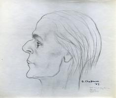
1937. Doris Emerson Chapman (age 34). "West Kennet Long Barrow [Map]. Age 35. Height 5.7."
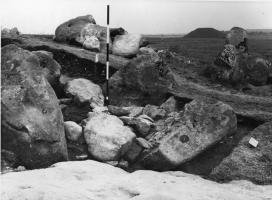
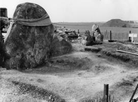
Photographs by Prof S Piggott and Prof R J Atkinson, 1955-56 taken during the excavation of West Kennet Long Barrow [Map]
1. The blocking of the forecourt of behind Stone 47 with Silbury Hill in the background.
2. Stone 45 being erected.

