Text this colour links to Pages. Text this colour links to Family Trees. Text this colour are links that are disabled for Guests.
Place the mouse over images to see a larger image. Click on paintings to see the painter's Biography Page. Mouse over links for a preview. Move the mouse off the painting or link to close the popup.
Wormhill, Derbyshire is in Buxton, Derbyshire [Map].

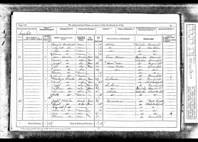
1871. Census. Wormhill, Derbyshire [Map].
Joseph Fletcher (age 41). 35. Quarryman.
Sarah Yates (age 35). Wife. 35.
John Fletcher (age 9). Son. 9.
Joseph Fletcher: In 1830 he was born to John Fletcher at Peak Forest, Derbyshire [Map]. In July 1911 he died at Chapel en le Frith, Derbyshire [Map].
Sarah Yates: In 1836 she was born. In 1923 she died.

On 31st December 1883 John Fletcher (age 21) and Emma Stafford were married at St Thomas Becket's Church, Chapel en le Frith [Map]. He was resident at Dove Holes, Derbyshire [Map], she at Wormhill, Derbyshire [Map].
Bole Hill Barrow, Wormhill, Buxton, High Peak, Derbyshire, North-Central England, British Isles [Map]
Bole Hill Barrow is also in Peak District Bronze Age Barrows.
Thomas Bateman 1846. On the 15th of August 1846, another barrow [Bole Hill Barrow [Map]], on higher ground, a little farther on the opposite side of the road to Buxton, was opened. Its diameter is greater than that of the last, but, like it, is surrounded by a circle of very large stones. In the centre was an erection of very large flat stones, regularly walled in courses, and having for its base a piece of rock four feet by five, and one foot thick, approaching to a ton weight, so that if the earthy part of this barrow had been carefully removed so as to leave these stones undisturbed, there would, according to the old school of antiquarianism, have been a complete druidical circle, with a cromlech or altar for human sacrifices standing in the centre; more particularly, as the flat stone at the top of the central pile had a considerable inclination towards one side, which peculiarity in similar structures has been gravely accounted for as an intentional provision to carry off the blood of the unfortunate victims now and then sacrificed by the Druids. But to return to the funereal discoveries made in this barrow; on removing the aforesaid large stone, a few pieces of an unusually coarse urn, some calcined human bones, and the remains of a host of rats, with here and there a skull of the weasel, appeared; though level with the surrounding field, the earth under the stone was loose, and had been removed to form a cist, 'which had for its floor a level surface of rock, some three feet below the natural soil, and which was neatly walled round with flat stones; in this grave was a skeleton of large dimensions, lying on its left side, in a contracted posture; behind the head was a brass dagger of the usual type, measuring six inches and a quarter in length, and in the highest preservation; it has the appearance of having been silvered, and still retains a brilliant polish; when deposited it had been inclosed in a wooden sheath, the remains of which were very perceptible at the time of its discovery. Near it were two instruments of flint, and two more were found during the progress of the examination of the tumulus.
![]() Become a Member via our Buy Me a Coffee page to read more.
Become a Member via our Buy Me a Coffee page to read more.
Bole Hill Barrow 2, Wormhill, Buxton, High Peak, Derbyshire, North-Central England, British Isles [Map]
Bole Hill Barrow 2 is also in Peak District Bronze Age Barrows.
Thomas Bateman 1846. On the 19th of August 1846, was opened a barrow [Map] [Note. Bole Hill Barrow 2 [Map]] near the last, much mutilated by the removal of a quantity of stone for fencing, at the time of the inclosure of the common, when, if report be true, two celts of bronze were here discovered. A considerable portion of the circle still remaining, gave hopes of something still untouched, and to be obtained without much labour; but upon examination, the unremoved part of the mound proved to be mainly undisturbed rock, slightly covered with stones and soil, amongst which were found two skeletons, one male, the other female; the former lay close to the turf, and was of course much decayed and broken; the latter was deeper, in fact, it lay upon the surface of the rock, and was in much better preservation; near them were some small pieces of flint, and one small piece of an urn. Below that part of the tumulus that had been carried away was a small deposit of calcined bones, accompanied by those of the rat.
Higher Bibbington, Wormhill, Buxton, High Peak, Derbyshire, North-Central England, British Isles [Map]

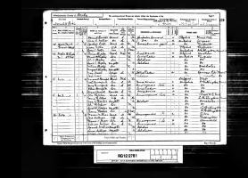
1891. Census. Higher Bibbington [Map]. No. 3. Second Row.
John Fletcher (age 29). Head. 29. Quarryman.
Emma Stafford. Wife. 26.
Wind Low Barrow, Wormhill, Buxton, High Peak, Derbyshire, North-Central England, British Isles [Map]
Wind Low Barrow is also in Peak District Bronze Age Barrows.
Thomas Bateman 1846. On the 12th of August 1846, was opened a low flat barrow at Windle (Wind Lowe) Nook [Map], near Hargate Wall, Derbyshire, about twenty yards in diameter, two feet high, and encircled by a ring of large flat limestones, placed in a sloping manner on one side, about three yards from the margin of the tumulus, apparently for the purpose of preserving its symmetry. The top of this barrow is surmounted by a large square sandstone, which has originally formed the base of one of the wayside crosses, of which numerous examples remain in the north of Derbyshire. About the centre of the barrow was a cist, measuring near six feet by four, in horizontal area, and three feet in depth, of unusual construction, the sides being built of large stones set on end, some of which appeared above the turf; an examination of the contents of this cist led to the conclusion that it had been applied to sepulchral purposes at various distinct periods, and that the last interment had been partially disturbed at a comparatively recent period; the contents were as follows: small pieces of urn, calcined bones and flints, skeletons of two persons of full stature, and of two infants, one of them very young, and various animal bones, amongst which, those of the rat, weasel, and horse were most conspicuous. All these articles were so much out of their ordinary arrangement, as to leave no doubt of their disinterment at the time of the burial of another skeleton, which lay in a contracted position a few inches above the floor of the vault; this skeleton, which, from the ornaments discovered with it, and the slender proportions of the bones, must be attributed to a female, had not entirely escaped spoliation at a recent period; the following circumstances seem to put this question beyond doubt, namely, the discovery of sundry pieces of tobacco-pipe, and nails from rustics' shoes, and from the fact of finding part of a very large ivory pin, and a fragment of an armilla or bracelet of Kimmeridge coal, both of which would undoubtedly have been perfect at the time they were deposited. Whoever these former excavators were, they were not very close observers as they had overlooked a necklace of beads of the aforesaid Kimmeridge coal, terminated by two perforated conical studs of the same, and enriched by six pieces of ivory, ornamented with the everlasting chevron or zig-zag pattern so universally prevalent on Celtic remains. The beads, exclusive of the studs and ornaments, are seventy-six in number, and are identical with two that are figured in plate 3, vol. i of Sir. Richard Hoare's excellent work. The ivory ornaments are quite novel, no other example having been published.
Note. The necklace discovered at Wind Low on display at Weston Park Museum, Sheffield [Map].
![]() Become a Member via our Buy Me a Coffee page to read more.
Become a Member via our Buy Me a Coffee page to read more.


Withery aka Withered Low Barrow, Wormhill, Buxton, High Peak, Derbyshire, North-Central England, British Isles [Map]
Withery aka Withered Low Barrow is also in Peak District Bronze Age Barrows.
Thomas Bateman 1846. On the same day two barrows on a very elevated piece of land on Wormhill Moor, known by the name of Whithery Lowe [Map], were opened; the smallest is situate on the highest point of the hill, and is formed almost entirely of soil, with here and there a stone. In it no symptoms of sepulchral remains were observed. The larger one is nothing more than the base of a considerable tumulus which has been removed to within eight inches from the natural soil; in the centre there was still remaining a cist, with a level floor formed of a slab of limestone; in this were the remains of two bodies, one of them a female, both which had been broken and disturbed at the time of the removal of the upper portion of the barrow.