Text this colour links to Pages. Text this colour links to Family Trees. Text this colour are links that are disabled for Guests.
Place the mouse over images to see a larger image. Click on paintings to see the painter's Biography Page. Mouse over links for a preview. Move the mouse off the painting or link to close the popup.
Knockeen Portal Tomb is in County Waterford, Prehistoric Ireland.
Llewellynn Jewitt 1870. Other excellent examples of Irish cromlechs and chambers are those at Monasterboise ("Calliagh Dirras House") [Map]; Drumloghan (full of Oghams) [Map]; Kells; Knockeen [Map] (figs. 47 and 48); where the right supporting stones are six in number, and arranged rectangularly, so as to form a distinct chamber at the S.E. end, the large covering stone being 12 feet inches by 8 feet, and weighing about four tons, and the smaller one about half that size; Gaulstown [Map] (figs. 49 and 50, the inner chamber of which measures 7 feet by 6 feet 4 inches, and is seven feet in height); Ballynageerah [Map] (figs. 51, 52, and 53), the capstone of which is cleverly and curiously poised on two only of the upright stones, as will be seen by the engravings1; Howth, Shandanagh, Brennanstown, Glencullen, Kilternan, Mount Brown, Rath-kenny, Mount Venus, and Knock Mary, Phoenix Park, as well as at many omer places.
Note 1. For the loan of these seven engravings I am indebted to the Council of the "Historical and Archaeological Association of Ireland," (formerly the "Kilkenny and South-east of Ireland Archaeo'ogical Society,") in whose journal one of the most valuable of antiquarian publications they have appeared. This Association is one of the most useful that has ever been established, and deserves the best support, not only of Irish, but of English antiquaries.


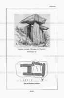
Journal of the Kilkenny and South-East of Ireland Archaeological Society Volume 5 1866 Pages 476-482. The illustration, Plate I, representing the cromleac in the townland of Knockeen [Knockeen Portal Tomb [Map]], at S. E. corner of the termon wall of the old church (near Sporthouse), Co. Waterford, affords an example of the two peculiarities alluded to ; and the whole structure is remarkable for its solidity, and the perfect carrying out of a unity of design.
The orientation of this structure is N. W. and S. E. ; the open end, or that presented to the view in the engraving, being that facing to the N. W.
The upright supporting stones are six in number, and are arranged rectangularly, so as to form a distinct chamber at the S. E. end, measuring 7x4 feet, by 6 feet 6 inches in height ; the side stones at the N. W. end projecting beyond the transverse or diaphragm stone a distance of 3 feet 6 inches.
The large covering slab measures 12 feet 6 inches x 8 feet, with an average thickness of 1 foot 6 inches, thus giving a weight of something like 4 tons ; the supplemental covering stone measuring 7 feet x 8 feet.
The height of the supporting stone nearest in the view is 8 feet 6 inches above the present level of the ground and the total height of the structure to the top surface of the large covering slab is 12 feet 6 inches : at the open or N. W. end the supporting stones are 3 feet 3 inches apart. The blocks are formed of the rudely cleaved felspathic dark grey trap of the district.

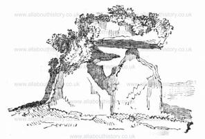
Dublin Penny Journal 1833 Page 245. Cromleach, at Knockeen [Map], County of Waterford.
The annexed cut is a faithful representation of a Cromleach at a place called Knockeen, about five miles north of the celebrated watering-place, Tramore, in the County of Waterford. I should more properly have written that my drawing correctly represents what that Druidical monument was in the year 1825, because I cannot say what damage it may have since received, as I have not seen it for the last seven years.
The word Cromleach is from the Irish, Cromleac, a pagan altar, which is a compound of, Crom, God, and leac, a flat stone. The one now about to be described is situate on the gentle declivity of a small hill, as the name of the place, i. e. "the little hill," indicates, and was constructed of eight huge rocks, six of which stood upright, and the remaining two were laid flat upon some of the erect ones. One of the latter stones, which is about sixteen feet in length, and of proportionate breadth and thickness, weighing five or six tons, appears to have been balanced on the top of one of the upright rocks, as on a pivot. At the time I saw it, one end of this stupendous block seemed to be suspended in the air, but the other end was overgrown with ivy, which con- nected it with the stones beneath, and gave the whole group a very fantastic and grotesque effect. It is to be remarked that this structure lay due east and west, in conformity with the ancient custom, which assigned amongst the cardinal points a religious pre-eminence to the east. 1826. This superiority of the east over the other points of the compass in religious worship at the first glance strikes one as strange, nay, almost, as pagan and ridiculous, but many important reasons for its continuance are to be found in an anonymous work, entitled " The Picture of Parsonstown," published by subscription in The author of that work, in describing the new Roman Catholic Chapel of Parsonstown, animadverts on the In position in which that edifice was placed, and quotes from scripture, the primitive fathers, and profane writers, a Egeat number of curious and interesting authorities on the subject.
![]() Become a Member via our Buy Me a Coffee page to read more.
Become a Member via our Buy Me a Coffee page to read more.