Text this colour links to Pages. Text this colour links to Family Trees. Text this colour are links that are disabled for Guests.
Place the mouse over images to see a larger image. Click on paintings to see the painter's Biography Page. Mouse over links for a preview. Move the mouse off the painting or link to close the popup.
Avebury Late Neolithic Early Bronze Age is in Avebury.

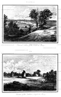
Colt Hoare 1812. Plate XIV. No. 1. This view which is taken from the vallum of Abury, looking north-west towards the village of Monkton, wili point out the farm of this huge rampart; and the only stone remaining within the compass of this view, will indicate the nature of the outward circumvallation. A road leading from Abury to Oxford intersects the vallum in a line from north to south.
Plate XIV. No 2. This is the most perfect view that can, alas! be at present obtained of this mighty work. It represents two upright, and three fallen stones of the outward circle of the Southern temple. Beyond them, are two stones of the outward circumvallation; near them is the turnpike house; and beyond it one of the stones which formed the commencement of the Kennet avenue.

Colt Hoare 1812. Plate Xl. By this plan I have been anxious to convey to my readers, correct idea of the grand circle at Abury in its original state, as most ingeniously developed by Dr. Stukeley. The site of the temples is taken from nature. The fine British earth-work called Oldbury Castle, appears at a distance in the centre of the view. The object of this Plate is to indicate the respective site of each temple; and the number of stones with which each composed; thirty in the out-ward, and twelve in the inner circles. The one situated towards the north, or right hand side, had three large upright stones in the centre of its area, designating the COVE [Map], where the altar was placed. The centre of the Southern Temple was marked by an upright stone named the OBELISK [Map], in a line with which, and between the temple and the outward circumvallation, was another single stone, with a perforation in it and denominated by Stukeley, the RING STONE [Map]. To this he supposes the victim was fastened previous to its sacrifice. The stones that accompanied the outward circumvallation, amounted to one hundred. The breaks in the vallum A. [Map] B. [Map] point out the spots where the two avenues issued from the central Temple; the one on the left side leading to Kennet; the other towards the centre to Beckhampton.